Scans In, Pointclouds Out
In January 2022, Point3D was contracted to document the existing conditions of a commercial office building in Toronto, Ontario using 3D Laser Scanning. The project consisted of nearly 300 scan setups collecting millions of LiDAR measurement references, hundreds of 360-degree images, and infrared sensor data.
Each 3D scan was cleaned and registered with multiple links to ensure an accurate point cloud bundle. The combination of all 3D scans captured produced a dense, RGB-coloured point cloud providing a full understanding of the building’s dimensions and current condition. After registration was complete, a registration report confirmed the overall accuracy of the building spatial data. Essentially, this point cloud serves as a dimensionally accurate digital twin of the actual building.
Once digitally constructed, the final point cloud is exported into .RCP and .LGS file formats for both designers and non-technical project stakeholders to view. The video below shows the process of registering the 3D Laser Scan data in Leica Register360.

3D Laser Scanning
3D Laser Scanning is a reality capture method employed to measure the dimensions and geometry of existing structures more efficiently and accurately than traditional tools used for site measures. Put simply, 3D Laser Scanning helps to digitize the built environment. Millions of LiDAR measurement reference points and a 360-degree image are captured at the same time with every scan setup. Together, all as-built references, both dimensional and visual, are documented for further architectural and engineering analysis.

3D Laser Scan Registration
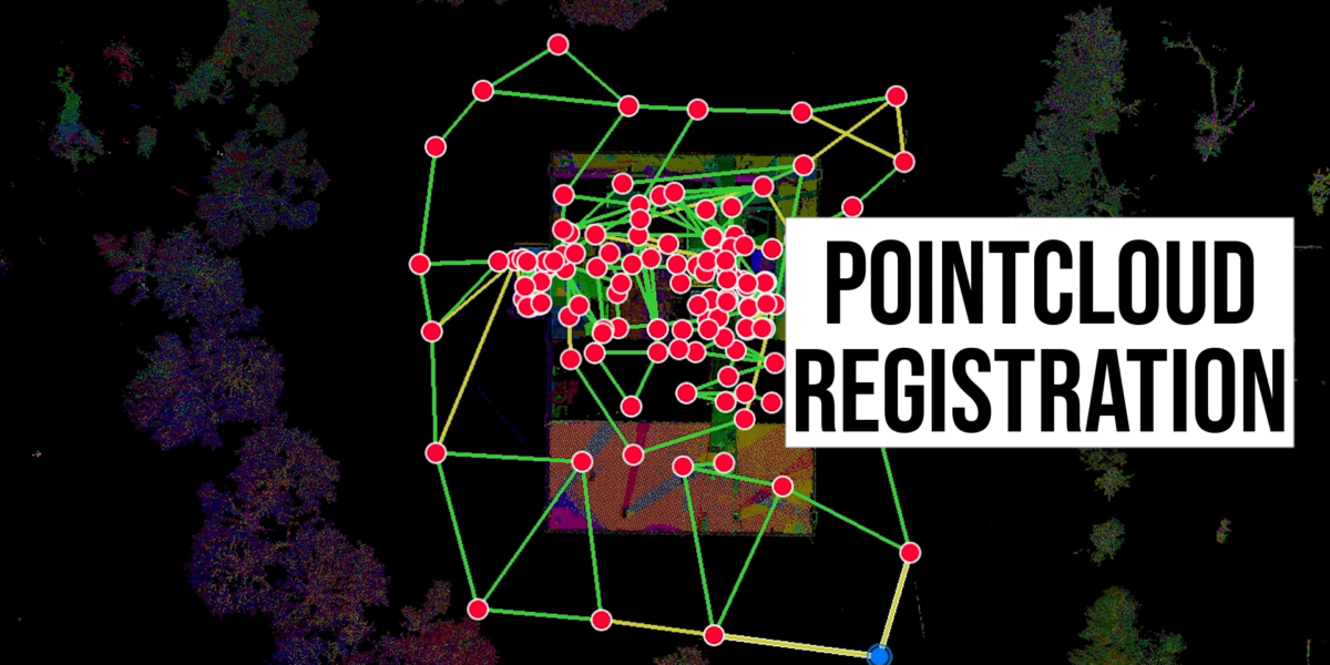
The dataset from each 3D scan setup must be registered to produce an accurate point cloud file. Best practices include having at least one link with another setup to ensure the best overall accuracy of the final point cloud file. This is completed with a combination of automatic and manual visual alignment. Scan data points are matched with those from other scans as accurately as possible. Typically, in a 3D scanning project, there are pre-registered and unregistered 3D scans, all of which are visually checked for proper registration during the final quality assurance process.
The benefits of introducing point clouds into the as-built development workflow are literally immeasurable.
For project delivery, the finalized or registered point cloud is typically made available in two formats. The first file format, .RCP, is specifically for professional architects and engineers. The second, .LGS, is a lightweight and easily accessible version of the point cloud which is accessible to almost anyone. While both formats are provided and can technically be opened for free (.RCP with Autodesk Recap, .LGS with Leica Truview), we have the following recommendation:
- The .RCP point cloud: Used with the Autodesk suite of products including, but not limited, Autodesk Revit, Autodesk AutoCAD, and Autodesk Civil 3D. The point cloud along with Autodesk Recap Pro is used to create Building Information Models eliminating the need for repeat job site visits for measuring and modelling.
- The .LGS point cloud: Preferred by some designers for use with measuring and visual confirmation of as-is building conditions, the .LGS file can be faster to load on most machines than Autodesk Recap. There are also additional features such as HDR images and IR-sensor information exclusive to the .LGS point cloud file. Also, it shouldn’t be discounted that the .LGS can be easily downloaded by any project or company stakeholder. The .LGS point cloud used with Leica Truview allows users to explore the point cloud similar to a virtual tour. This has proved to be an efficient way to receive boots-on-the-ground building intelligence without actually having to show up on site.
While .RCP and .LGS files are the most popular with our clients, Point3D is able to provide other industry standard formats such as .e57, .pts/.ptx, and .las, depending on the intended use downstream.

Why Point Clouds for As-Built Conditions?
By using point clouds captured with a calibrated laser scanning device and properly registered by a competent point cloud specialist, architects, engineers, and forward-thinking developers can efficiently produce accurate as-built drawings at scale. While an architect and apprentice can no doubt properly measure the existing conditions of a building, there exist many areas where major human-error can occur throughout the workflow. At scale, missed measurements, inaccurate measurements, and poor documentation practices can cause disaster to a project’s timeline. That’s why we are seeing more architects and developers in Toronto and Ottawa looking to Point3D Commercial imaging to promptly provide documentation by capturing point clouds with 360-images to produce Revit as-built models and AutoCAD as-built drawings. The benefits of introducing point clouds into the as-built development workflow are literally immeasurable.
We are 3D Point Cloud Specialists
3D Laser Scanning offers a major advantage to traditional building survey and site measure processes. If you are interested and looking to learn more about using point clouds in Ottawa, Montreal or Toronto, get in touch with our team to schedule your 3D Laser Scan.